
Collaborators
City Research Team Members

Implementing Partner

Local Partners

Sakiya is a progressive academy for experimental knowledge production and sharing, grafting local agrarian traditions of self-sufficiency with contemporary art and ecological practices. This circular system of knowledge production and sharing integrates agriculture within the framework of an interdisciplinary residency program, where cultural actors, such as farmers and crafts/small industry initiatives, assume a prominent role alongside local and visiting artists and scholars. Sakiya’s core programs engage food production, exhibitions, symposia, publications, and education/training workshops, exploring the intersections between art, science, and agriculture in a sustainable and replicable model.
Sakiya envisions liberation through a society whose confidence is rooted in traditional and contemporary ecological practices, whose tolerance echoes nature’s diversity, whose generosity springs from collective labor, whose creativity is enriched by the intersections between art, science, and agriculture, and whose prosperity is shared beyond boundaries.
Visit Sakiya's website here.Co-Applicant
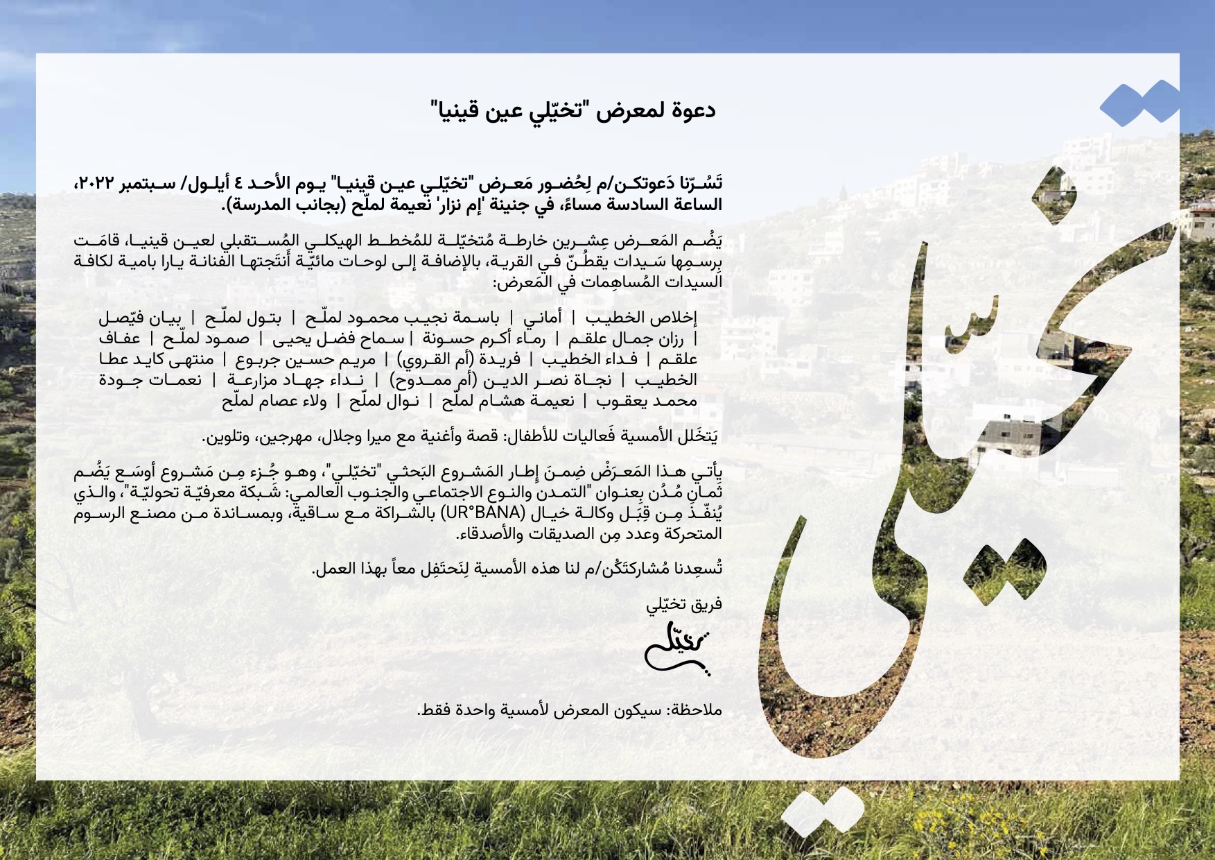
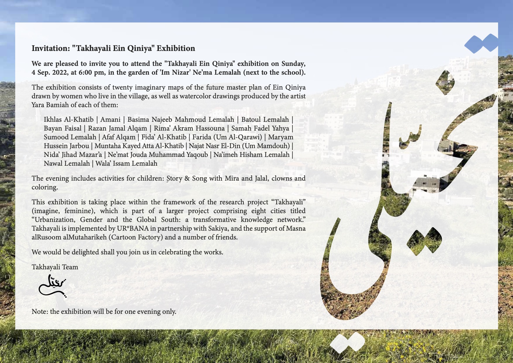
Takhayali EQ Exhibition
In September 2022, GenUrb’s Ramallah CRT hosted the Takhayali EQ Exhibition in Ramallah. The program focused on the community of residents in Ein Qiniya, particularly the Narrators and children. It was attended by about 120 adults and what felt like 60 children. A speaker on behalf of the village council confirmed that the proposals by the Narrators will be examined. It was covered by 2 local TV channels and 1 radio.
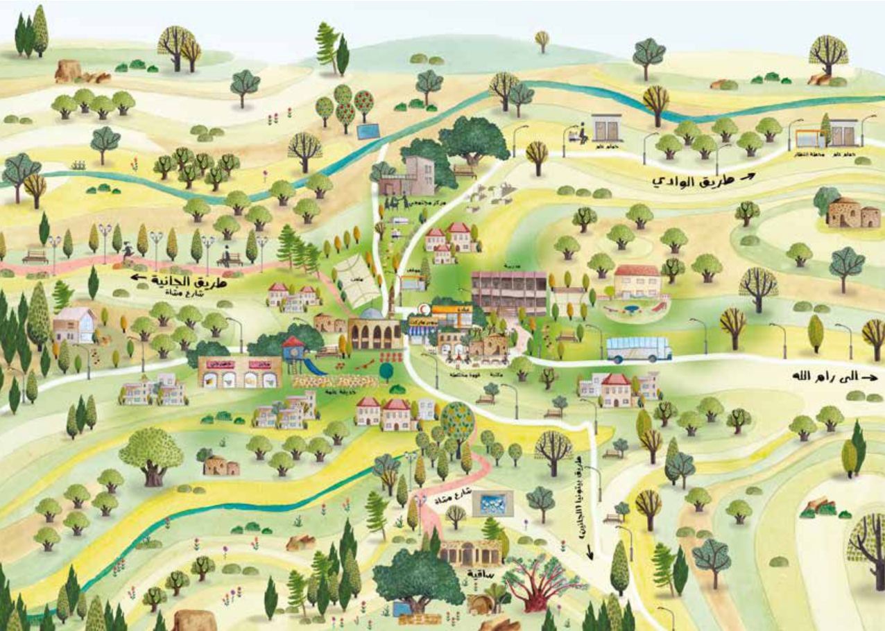
We have attached invitations and copies of postcards about re-imaginging Ein Qiniya that were displayed at the event.
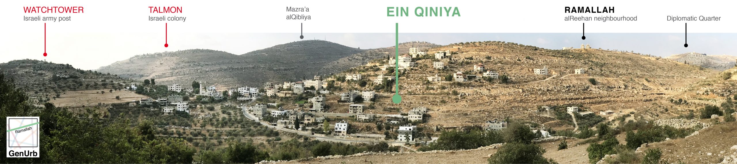
Ein Qinya
Ein Qiniya (EQ) is located at the north-western edge of what today is the official Municipal boundary of Ramallah, and according to the Ministry of Local Government, it is part of the RABMA: Ramallah, alBireh and Beitunya Metropolitan Area. Archeological remains date EQ back to the Bronze Age (3300-1200 BCE), although it is not clear if it was constantly inhabited. Like most Palestinian settlements, it lies on the slopes of a hill facing a valley. In spite of the rapid expansion of most of the tangent and neighbouring cities, towns, and villages in the last 2 decades, EQ remains quite small due to the fact that 12% of its area is classified as B Areas (under Israeli security control, civil administration by Palestinian Authority) and most of its lands beyond the residential core, 88%, are classified as C Areas (under full Israeli control, much declared as natural reserves banning any activities in it). Further, EQ is a ‘dead-end’ – at its western end its main road is blocked by an Israeli Army watchtower and closed checkpoint (it leads to the Israeli Dolev colony built on the lands of EQ, a mere 1.5 km away, and a bit more to the north the Talmon and Talmon A colonies), and until 2010 its eastern entrance was blocked by another checkpoint that restricted entry to and from Ramallah. Since the removal of barriers separating it from Ramallah a few years ago, the terraces and valley of EQ have turned to the largest informal natural park that residents of Ramallah spend time in on free days.
Most of the lands of the Ein Qiniya are owned by people from Ramallah, either historically or acquired by speculative investors during recent years in anticipation of its annexation to expanding Ramallah (as happened with parts of Surda, to the east of EQ, in 2012) and the ensuing spike in property value. The proximity to Ramallah has influenced life in EQ in many ways, among which an utter dependency in terms of services whether health, education, or groceries among other everyday needs as well as, to a large extent, employment. However, traditional ways of living and family norms are still strong in EQ, and a small number of families remain successful in farming (mostly leased lands) where they rely on agriculture and traditional crafts to earn a living. Noteworthy, agriculture remains common in EQ and surrounding areas due to the availability of natural springs and streams, as the high prices of water and land continue to undermine the viability of agriculture – and therewith food sovereignty – in the West Bank. There are no official statistics regarding waged employment of women in EQ, yet initial research indicates that women are involved in (unpaid) farming activities, are the caretakers of households, and only a few have paid jobs.
The community in Ein Qiniya is composed of the original families of the village that returned after their expulsion in 1917 by the British colonization, and ‘newcomer’ families that relocated to EQ after being forcefully displaced by Zionist militias in 1948 from areas within the Green Line. Local sources say EQ is currently inhabited by around 1,000 persons, while official statistics put the number around 800 persons.
تقع عين قينيا على الحافة الشمالية الغربية لما هو اليوم الحد الرسمي لبلدية رام الله ، ووفقًا لوزارة الحكم المحلي ، فهي جزء من منطقة رام الله، البيرة، وبيتونيا المتروبوليتية. تعود البقايا الأثرية إلى العصر البرونزي (٣٣٠٠-١٢٠٠ قبل الميلاد)، لكنه ليس من الواضح ما إذا كانت مأهولة باستمرار. مثل معظم المستوطنات الفلسطينية، تقع على سفوح تل مواجه للوادي. على الرغم من التوسع السريع في معظم المدن والبلدات والقرى المماسية والمجاورة في العقدين الماضيين ، لا تزال عين قينيا صغيرة جدًا نظرًا لأن ١٢٪ من مساحتها تصنف على أنها مناطق ب (تحت السيطرة الأمنية الإسرائيلية، الإدارة المدنية من قبل السلطة الفلسطينية) ومعظم أراضيها خارج النواة السكنية، ٨٨٪، تصنف على أنها مناطق ج (تحت السيطرة الإسرائيلية الكاملة، وتُعلن الكثير أنها محميات طبيعية تحظر أي أنشطة فيها). علاوة على ذلك، تعد عين قينيا “طريق مسدود” – في نهايتها الغربية يتم حظر طريقها الرئيسي من قبل برج مراقبة تابع للجيش الإسرائيلي ونقطة تفتيش مغلقة (تؤدي إلى مستعمرة دوليف الإسرائيلية المبنية على أراضي عين قينيا، على بعد ١.٥ كم فقط، و اتجاهاً أكثر قليلاً إلى الشمال مستعمرات تلمون وتلمون أ)، وحتى عام ٢٠١٠ كان مدخلها الشرقي محظور من قبل نقطة تفتيش أخرى قيدت الدخول من وإلى رام الله. منذ إزالة الحواجز التي تفصلها عن رام الله قبل بضع سنوات ، تحولت المدرجات ووادي عين قينيا إلى أكبر حديقة طبيعية غير رسمية يقضي فيها سكان رام الله وقتًا في وقت الفراغ.
معظم أراضي عين قينيا مملوكة من قبل أشخاص من رام الله، إما تاريخياً أو حصل عليها مستثمرون مضاربون خلال السنوات الأخيرة تحسباً لضمها لتوسيع رام الله (كما حدث مع أجزاء من سردا، شرق عين قينيا، في عام ٢٠١٢) وارتفاع لاحق في قيمة العقار. لقد أثّر القرب من رام الله على الحياة في عين قينيا بعدة طرق، من بينها التبعية المطلقة فيما يتعلق بالخدمات سواء الصحة أو التعليم أو محلات البقالة والاحتياجات اليومية الأخرى وكذلك إلى حد كبير العمالة. ومع ذلك، لا تزال الطرق التقليدية للمعيشة والأسرة قوية في عين قينيا، ولا يزال عدد صغير من الأسر ناجحًا في الزراعة (معظمها من الأراضي المؤجرة) حيث يعتمدون على الزراعة والحرف التقليدية لكسب العيش. والجدير بالذكر ان الزراعة لا تزال شائعة في عين قينيا والمناطق المحيطة بها بسبب توفر الينابيع الطبيعية والجداول، حيث أن ارتفاع أسعار المياه والأراضي يواصل تقويض صلاحية الزراعة – وبالتالي السيادة الغذائية – في الضفة الغربية. لا توجد إحصاءات رسمية بشأن العمالة المأجورة للنساء في عين قينيا، لكن الأبحاث الأولية تشير إلى أن النساء يشتركون في أنشطة زراعية (غير مدفوعة الأجر)، وأنهم من يتولون رعاية الأسر، وأن قلة منهم فقط لديهم وظائف مدفوعة الأجر.
يتكون مجتمع عين قينيا من العائلات الأصلية للقرية التي عادت بعد طردهم في عام ١٩١٧ من قبل الاستعمار البريطاني، وعائلات “الوافدين الجدد” التي انتقلت إلى عين قينيا بعد أن نزحتها المليشيات الصهيونية بقوة في عام ١٩٤٨ من مناطق داخل الخط الأخضر. تقول مصادر محلية أن عين قينيا يسكنها الآن حوالي ١٠٠٠ شخص، في حين تشير الإحصاءات الرسمية إلى أن الرقم حوالي ٨٠٠ شخص.